Saturday, 25 July 2015

Te Henga (Bethells) - Wainamu Lake - Houghton Track - Wainamu Junction + Return via the opposite side of the lake

Date: 24 July 2015
Party: Anna, Elizabeth, Lesley
Map: 


Distance: 10.5 km
Elevation: 


Time: 3.5 hours
Notes: This is one of our favourite tramps. The black sand dunes are amazing (and who could not love that loo...). There is a huge nikau glade, fabulous swimming 'pools' that are really popular during summer, a Maori carving and even Barbie holidays here. Coming back to the car around the dunes from the other direction means a bit of a slosh through the stream, as there is no path other than up and over some pretty steep dunes. We managed to take a timed selfie (cos that is how we roll) which was entertaining. On our way back past the lake we met some nice regional council staff who were installing some kind of telecommunications equipment so that they are sent digital information about the lake - temperature, etc, rather than having to check their instruments manually, so we finally established what the buoys were for in the middle of the lake. There are apparently heaps of fish, but not native species - carp and perch - and they are quickly taking over. The water was amazingly clear though.


Saturday, 18 July 2015

Anawhata Road - Kuataika Trig - Wainamu Junction + Return

Date: 17 July 2015
Party: Anna, Elizabeth, Lesley
Map:
Picture
Distance: 10.4 km
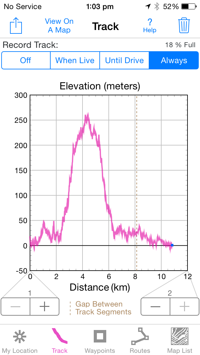
Elevation: 276m at Wainamu Junction
Time: 3 hours and 55 mins
Notes: Our initial plan was to walk through to Lake Wainamu and back, but the rain, conditions and need to be back by 4pm were against us and we only went to the Junction. Hopefully next week we can start at the other end and complete this section of the Hillary Trail. The track starts (unusually) with a paddock, and a brilliant view of the coast. It was pretty clear, though, from the valley in front of us, that there would be some peaks and troughs in this walk, and so there were (literally and metaphorically)! The track is wide, most probably a 4-wheel drive track, and it is rocky, muddy and slippery. This is not a track to do after heavy rain. We descended quickly to the valley floor, having to watch every step, crossed a small river or two, then ascended to the trig. This section was a bit of a slog through regenerating bush...there were lots of juvenile natives, but also lots of gorse, cutty grass, manuka and kanuka. The trig gives you a panoramic view of the coast and valley, and is a great place for morning tea. We were lucky enough to enjoy no wind and bright sunshine at the trig (must have been in Auckland) so we could mentally have some respite from all that slippery mud. Back down to the track and we continued our ascent to the Junction. Decision made to turn around at this point, we retraced our steps, with several bone-jarring falls that confirmed our position of glad-we've-done-it-but-never-again. All you can say about this trip is we are getting better at stream crossings. Boom. That's it. Back to Little Sister Cafe to celebrate.


Trig on the hill on the horizon
Grevillea perhaps?


Saturday, 4 July 2015

Nihotupu Dam Track - Christies Track + Return

Date: July 3 2015
Party: Anna, Elizabeth, Lesley
Map: http://photos2.meetupstatic.com/photos/event/1/8/9/4/highres_282126292.jpeg
Distance: 11.5 km
Elevation: ? Not huge
Time: 3 hours 55 mins
Notes: With Anna's Waitakere books and maps tucked into a box of unknown whereabouts in her new apartment, we took a punt on this in-and-out trip to the Nihotupu Reservoir. An easy walk to the dam, there is a dramatic drop and view across the valley on one side and a calm body of water on the other (yes, quite dam-like). We kept off the dam face, as requested, but were puzzled by the medieval instrument of torture (seen in picture 3 below). Seems a bit primitive to discipline your aberrant DOC workers by dangling them from that cage over the water (although the Kepler's dead-stoat-in-pocket, tardy, yoga guy might just need a dangle). Taking a sharp right at the end of the dam, we slid and slithered our way to the end of Christie's Track, where we crossed a small stream and ended up at Huia Dam Road. Concentrating on our foot placement in all that mud, we had been oblivious to our surroundings, and only on the return journey appreciated the fungi, beautiful natives, lovely streams and waterfalls. We had lunch in the shelter by the dam, where a couple of dodgy looking chaps strolled past, and then met a party of four who were even dodgier. We were not surprised, then, to see some old not-so-fluffy dice swinging from a tree a little further on. The sights you see out West. We experienced some wet stuff too that seemed to fall from the ceiling of the world, which we later discovered is called 'rain'. Who knew? Home without refreshments with the promise of drinks in the new apartment...another Perfect Friday.


Clavaria roseoviolacea


Wednesday, 17 June 2015

Anawhata Road - Ridge Road Track - Simla Track - Sisam Track - Long Road - Anawhata Road

Date: 12 June 2015
Party: Anna, Elizabeth, Lesley
Map: http://www.topomap.co.nz/NZTopoMap/trck36182/Simla-Track/
Distance: 11 km? and have we now nearly walked the whole of the Hillary Trail?
Elevation: Plenty
Time: 4 hours and 25 minutes, with a couple of stops
Notes: Some weird and wonderful things:
1. After years of encountering only wildlife and the odd hunter, we encounter an entire film set, with catering vans, four-wheel drives, trucks, generators etc.
2. Our dedicated mycologist decapitates an unusual pale blue fungus, possibly Weraroa. We are shocked.
3. We discover an old University Tramping hut, just off the track. It has some fantastic stolen road signs. 
4. We laugh smugly at the cautionary sign, 'experienced trampers only', then spend the next hour destroying all the muscle fibres in our legs going down Simla swinging from trees and sliding in mud. There are 30 seconds of relief at the bottom of this 'slope' when we cross a small stream which was part of an old kauri dam (you can see the notch in the bank where the beam slotted in) before...
5. We repeat the same going up Sisam.
6. We are twice (twice!) given the call that the car is imminent...only it's not.
7. Not that we are in a hurry to finish, it's just that our legs are. 
8. We see a great range of small birds, and surely the George Clooney of woodpigeons. See below for talent portfolio.
9. We retire to Little Sister Cafe and share a Louise Cake Slice which is Out of this World.


Saturday, 30 May 2015

Arataki Visitor Centre - Slip Track - Pipeline Track - Hamilton Track - Nihotupu Dam - Incline Track (!) - Scenic Drive

Date: 29 May 2015
Party: Anna, Elizabeth, Lesley
Map: NZ Tramper; (includes the Summit walk, which we didn't do)
Distance: 17 km; An In and Out track with an unintended loop
Elevation: Not sure
Time: 4.5 hours
Notes: Started the day remembering the value of preparing the night before, as shorts, hat and gloves had vanished. A Friday Special in terms of weather, although it was colder than usual, and we saw plenty of steam rising off the bush and dam as the sun rose higher. Hunters must have been in the area - we saw a couple of pig dogs with gps antenna, and one unexpectedly and silently followed us, only being discovered when he butted the back of my boot! We gave way to him on the track and he calmly trotted off to butt a piggy trotter instead. A pretty walk, with some massive kauri, a wonderful kauri glade, and great views in several directions. Had a muddy slip on Slip track (bloodied knee), and had a slip of another kind when we confused Pipeline and Incline Tracks on the way back, Incline track being appropriately named. It was only as we struggled past a monster kauri that we realised we hadn't seen it on the way in...oops. It was also decided that we need a Paul Henry segment on each of our trips, given one of our party's over-assertive condemnation of him as a dick. The dam was gorgeous - no wind, perfect blue sky, ducks, steam, rushes - a very peaceful place. Due to our unexpected incline up Incline, we had to return to the Arataki Centre via Scenic Drive, which we have discovered is dangerously busier than you might expect - we try and avoid it whenever we can.


Sunday, 24 May 2015

Upper Kauri - Smyth Ridge - Wainamu - Long - Cascades car park.

I can't believe we went without Lesley!  But she had a princess to deliver to a ball, so Elizabeth and I stepped out on our own, on a route that was a mix of the familiar and the new.  We managed to cover a section of the Hillary Trail which we had not done before, which is unusual.  I thought we had just about got that wrapped. It took us 3.45 hours,but we were pretty focused.  Up the Heritage walk to Smyth Ridge Track, back along Wainamu, then down the Long Rd Track where we went so horribly wrong with Vivienne. No rain, lots of mud, but we covered the Wainamu Track which is signposted as 2 hours in less than one.  I inadvertently switched the GPS off, so our track record is a bit dodgy.  Elizabeth had a great sandwich; spinach, salami and maybe capsicum? Mine was a couple of defrosted cheese pizza thingies from the middle Eastern place at Pakuranga.   Delicious but not the same level of anticipation.