Saturday, 23 January 2016

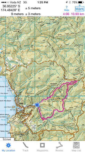
Glen Esk Road - Piha Valley Track - McKenzie Track - Quarry Track - McElwain Lookout - Centennial Track - Home Track - Connect Track - Kitekite Falls - Kitekite Falls Track - Glen Esk Road Car Park

Date: January 22, 2016
Party: Anna, Lesley
Map:


Distance: 11km
Elevation: 0-350 + 100-270 = 520 total


Time: Just over 4 hours, but we had an instagram stop (!) AND a longer lunch break than usual to watch the abseilers.

Notes: We are feeling the hot breath of Moss Pass in Nelson Lakes (March 2016) on our backs, so our first walks of the year are focused on elevation. Hills, and more hills. And lots of steps, just to mix it up. We discovered that the elevation difference between Blue Lake Hut and Moss Pass is about 600m (Moss Pass is 1785m high, Blue Lakes Hut is at 1190m, and it's about 1.7 km to the peak), so we are trying to make sure that we have a sense of how high and far it is, to consolidate our confidence. No paranoia here.... 

This is one of those walks you could recommend to someone else with a clear conscience. It has everything, and can be shortened or lengthened depending on what you want to do. The view from the lookout is amazing - we could see Te Toiokawharu in the distance and the west coast beaches stretching off to the right, with Piha directly in front of us. Hard to believe it had only taken a short while to get so far from where we had parked. We ran into Black Rock Dam on Centennial Track, which was in great shape - the water really clear and the remnants of the dam clearly visible in the structure. We wanted to have lunch at the falls, and joined the crowds of people (yes, crowds) soaking in the pools or canyoning or lounging on the rocks. What a novelty to come across anyone else! And as we walked down, we came across plenty of others headed up for a dip. The day was incredibly hot - late 20s - so that water looked pretty inviting. We loved the abseilers - one minute there was a sedate group of children splashing around, next there was a succession of people whizzing (or not) down the side of the falls. The instructor came down the ropes in the picture in about 3 seconds. We had coffee and gingerella (ok, and ginger crunch) at the Piha Cafe, which was really busy too - obviously we have never been to Piha in the summer! A great start to the tramping and walking year. Man, have we got plans!!


Gingerella
Steps up from the Dam
Kitekite Falls as we have never seen them before!

Black Rock Dam
Moss
So graceful!
Boulder Blonde
Upstream
Scribbles!
Found washed up on a log...


The Andrews Family (a special guest appearance!)


Maeve

John Beth and Lucy in San Francisco

John Lucy Maeve Ellis Beth
Lucy Maeve
Ellis Maeve Marta (?) John Beth


Sunday, 6 December 2015

Lone Kauri Road - Buck Taylor Track - Pararaha Valley - Muir Track - Walker Ridge - Orange Peel Corner - Odlin Timber Track - Lone Kauri Road


Date: December 4, 2015
Party: Anna, Elizabeth, Lesley
Distance: 10.5 km
Elevation: 370m
Time: 4 hours
Notes: Before we all head off our separate ways over Christmas, we thought a nice green walk in the Waitakeres was called for. We have done this walk before and on reflection it would be even better in reverse - coming out via the Pararaha Valley which is the best half of the walk. It would also mean that you don't have a mighty long uphill at the end on Odlins. One of the pleasures of walking a track more than once is the little rituals you develop and the anticipation of certain areas. The Valley is a good example: we check out the bulrushes; we look at how high the water is in relation to the boardwalk; we remember testing Anna's Tararua biscuit recipe with Debra Lockie, sitting on the boardwalk having a snack; we never fail to be excited to see the valley laid out in front of us; we take our boots and socks off to cross THAT stream - which has been high, low and frostily cold but always refreshing; we stop at the shelter for morning tea (or we move on if there are DOC staff cutting the grass, or a gaggle of students); we know there is a chain railing embedded in the rock further up from the shelter and that there is a stunning view at the top of this where we say again that we MUST walk up the valley to the waterfall one day - on a hot day, mind, maybe in February? - and we file that away. Somewhere in the middle of this circuit is the 'nest of vipers' too - a low point that is gloomy, wet, muddy and full of viperous tree roots and a tangle of hanging 'scribbles'. We recognise the little camping area by the stream. We notice, this time, the kanuka in absolute full luminous snowy bloom, and that the cabbage trees this year are extra-ordinary too (even the wee ones have flowered competitively this year). "Put that in the blog so we remember when they flower". The same track can surprise, too. We had sat down for second-lunch by the Pararaha Stream, eating an eccentric mix of antibiotics, cold potatoes and macaroni cheese, when three strapping chaps splashed into view from down-river. They had followed the river from the beach, swimming and climbing over rocks to this point, where they hopped out and ran up the Odlin stairs back to their car. We stopped them long enough to find out how they had done it, whether three only slightly middle-aged women could do it and how long it had taken them. When we saw them sprint off up Odlin we revised their suggested one and a half hours to more like three. They swam quite a bit of it and wore trainers, not boots, and we decided that we would have to attempt it ourselves this summer. Yup. I will be over my phobia of water by then, my therapist says so.